On the Trail of an Ancient Mystic

It isn’t just 19th century diaries or 1,000-year-old texts from where I draw my inspiration. Japan has a wonderful well of ideas to draw from in the many ancient roads that crisscross the landscape. Some, like the Kumano Kodo and Nakasendo are still comparatively well-travelled, even today.
Others, like the Koya Kaido, linking Kyoto to mystical Mount Koya, now lie half-buried under urban sprawl with their tales slowly fading from memory. And yet more lay hidden between mountains and within primordial forests, untraveled save for the occasional Yamabushi or adventurous spirit.
One of my great pleasures is seek out these unknown roads and try to unlock their mysteries as I follow their course. And close to the ryokan in southern Osaka at which I work, one tiny, obscure shrine turned out to be the gateway to a 110km trek that I am yet to complete.

The tiny shrine that first piqued my interest was hidden among the trees on a steep hillside at the top of the village of Nagaretani. It was signposted, although said signpost pointed only vaguely in the right direction and it still took some searching to locate it. Its was known as Katsuragi 28 Shuku Kyozuka Number 16.
If this was number 16, how many more were there? What were they? And where were the rest of them? I asked Okami-san and Shacho at the ryokan and they explained that they were part of a very old pilgrimage trail that mirrored the first path En-no-Gyoja forged through the mountains.
This ancient mystic was born in Katsuragi, just over the border in Nara Prefecture and wandered these mountains when he first started developing the idea that would become Shugendo, the ascetic form of training practised in the mountains by Yamabushi.

I found myself a map containing the rough locations of all 28 shrines that made up the pilgrimage and discovered that four of them were spread across the far south of Kawachinagano with Number 15 somewhere on Mount Iwawaki, and number 17 somewhere in the forest that marks the border with Wakayama Prefecture. Number 18 was further east, apparently close to a road that I never knew existed.

I started from Iwawaki-dera, a small temple on Mount Iwawaki. In almost perpetual shade thanks to the massive trees that tower over it, this mysterious temple dates back to the middle of the 16th century. According to my research, my first Kyozuka of the day, number 15, was only a few hundred meters up the winding road that leads towards the summit.
With only a tiny wooden sign and a slight gap in the trees to mark its approach, I very nearly missed it. The kyozuka itself was barely 200m from the road, up a slight rise and on the edge of a wooded outcrop. It was a very simple shrine, just a few small statues on a rocky base with a blanket of pine needles.
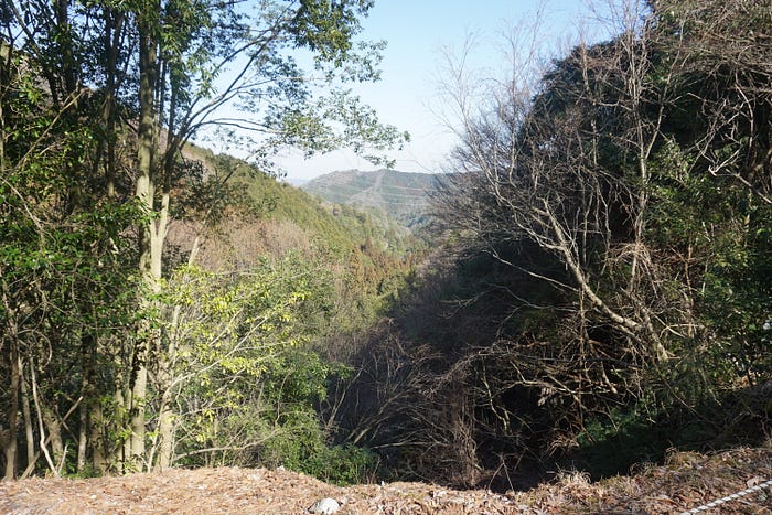
Previous visitors had left a shell, a smaller version of the conch horns used by Yamabushi, and what looked like coral. The spot was very peaceful, and an impressive view was just about visible through the thick trees. It was easy to see why a place like this would be important and why you would likely only find it if you were looking for it.
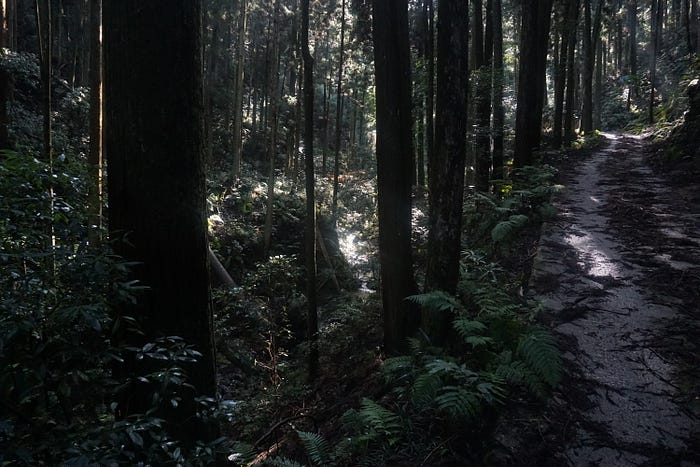
Rather than hike the popular Diamond Trail to my next destination, I took the more direct route along the road, away from Mount Iwawaki. The narrow road was very quiet as it swept down the hillside; with the thick forests of southern Osaka still surrounding me.
After some time, I came to a junction and took the road east. Climbing once again, this road was quite steep and covered in debris from the trees overhead, suggesting that it sees almost no traffic. Trail heads broke away from the road here and there, but I continued up and through a couple of short tunnels before it began to descend again.
I was once again in Nagaretani, high up on the west side of Amami village. Following the road down, I eventually found the sign suggesting where Kyozuka 16 might be. The narrow path followed a small stream and then turned up into a sparse bamboo grove on the edge of a wooded hillside. There were no more clear signs, however; I could see a rickety and slippery looking wooden ladder just beyond a fence built to keep the wild boar away.
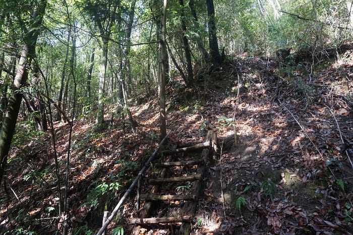
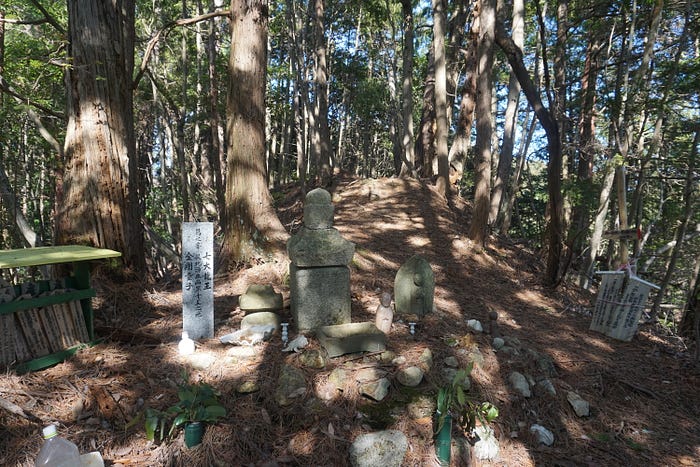
I hopped over the fence, tentatively climbed the ladder then navigated the narrow, slippery path along to the 16th shrine. Slightly larger than the previous Kyozuka, this one also had very little space in front of it. The thick layer of leaf litter made it a little tricky to keep one’s footing while paying respects, but challenge is a large part of Shugendo.
I slowly made my way back to the road and went down further into Nagaretani, passing by the “Thirteen Christian Jizo” carving and looking for the trailhead to take me to the next Kyozuka. Thankfully I already knew where I needed to go as the sign for the road I needed is virtually unreadable.
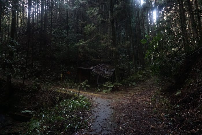
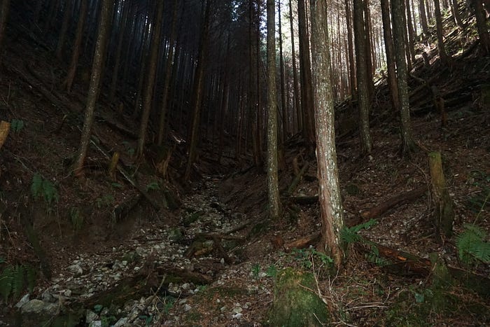
This muddy track turned south and followed the Amami river back up into the mountains. The dense trees blocked out most of the sunlight making the atmosphere dark, cool and slightly humid. After about 20 minutes I came to a junction with the remains of a small, collapsed building perched on top of the stream. The path to the right was blocked by several fallen trees, but my destination was up the path to the left.
Eventually, the path opened out into a muddy square with a small, metal bridge over the narrow river. On the opposite side of the bridge, the muddy track was replaced by a slightly steep hiking trail with plenty of tree roots breaking through the ground. All around me were signs of recent logging, perhaps trying to make the trail safer and more easily defined though it was not very tidy.

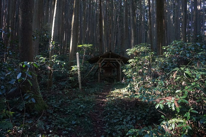
After a short distance, the trail changed once again to a stairway, shored up by logs and with the occasional log bridge to cross the stream. The condition of the trail was quite poor, with many fallen trees to navigate, but eventually the steep slope levelled off and then began to descend again until I finally reached a small clearing with a few benches. I was now on the Diamond Trail at a rest stop a few kilometers east of Mount Iwawaki. It was also the location of the 17th Kyozuka, just off the trail a short distance away.

This shrine was quite a bit larger than both previous ones and also felt a lot more mysterious. It is just far enough off the trail that most people who pass this way probably don’t pay it much attention and just see it as something of a curiosity.
After a quick lunch, I decided to press on along the Diamond Trail. I still wanted to try and reach the 18th Kyozuka, though this was quite some distance away. It was getting towards mid-afternoon so rather than back-track, I looked for an alternative route back to civilization so that I wasn’t stuck in the woods in the dark.
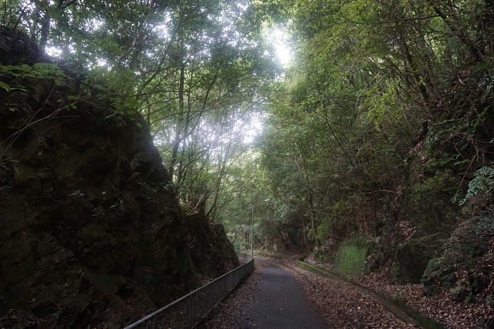
After passing through another poorly maintained stretch of trail, I eventually came to a junction. To the east was Kimitoge, a village in the far north of Wakayama Prefecture and to the south, a route back to Amami. Given the hour, I chose to take the route back down to Amami and followed a steep hill down. This long, straight road looked to be an access to a derelict vinery I had passed earlier and was in relatively good condition, so I made good time.

Eventually the trees thinned, and I found myself back in Nagaretani, about 1km from the previous trail head. There was still some daylight left and I now had two options for trying to reach the 18th Kyozuka buried in the woods between the villages of Chihayaguchi, Amami and Shimanotani.
I could walk along the pedestrian only road that follows the old Nankai Koya railway line between Amami and Chihayaguchi and then follow a narrow farming track up to the shrine. Or I could head up through Shimanotani then hike a short distance to a crossroads known as Jujitoge then turn north to reach the shrine from the opposite side.
Again, I opted for the quickest route along the old Koya Line because this would at least keep up close to a station in the event that I ran out of time. However, by the time I reached the bottom of the farming track, the light was beginning to fade so I called it a day and headed home.
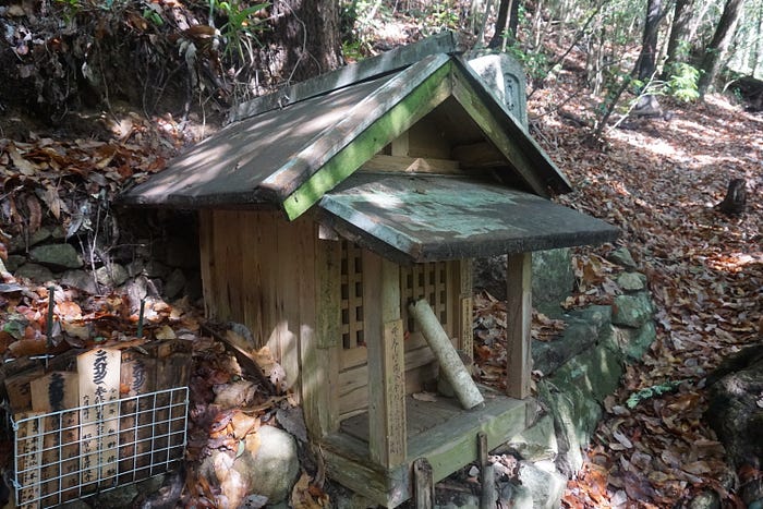
A few days later, I made my way back to Chihayaguchi Station, determined to locate the last of the four Kyozuka in Kawachinagano. I found the farming track after some 15 minutes of walking but before I began my climb, I stopped at an unusual and ancient looking shrine partially built into the hillside. Local legend states that the purpose of this “Sai-no-Kami” is to draw evil spirits out of the surrounding woods.

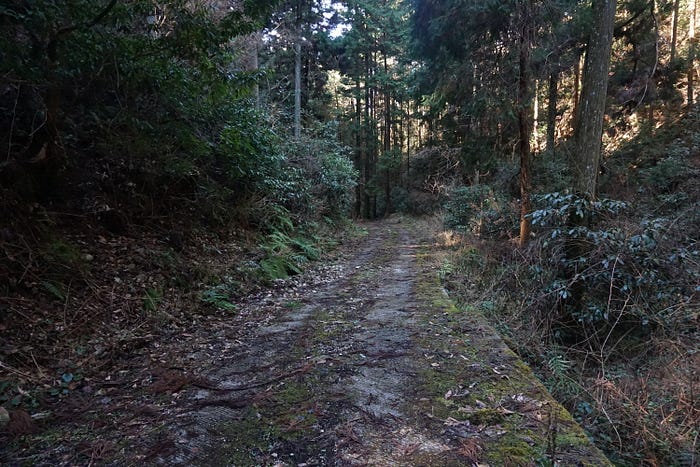
The track was paved but steep and it did not take long before I had left the sun behind and entered the gloom of the forest once again. A thick covering of leaf litter suggested that this road was also travelled only rarely and ran alongside another small river.

There was no sound except for the trickle of the river as I trudged upwards. There was also very little of note aside from a large area off to one side of the road which had hundreds of logs stacked up for growing shiitake.
Of more pressing concern to me was a lack of signs and even the red tags that sometimes mark trailheads were missing. After about 30 minutes of walking, I did spot a white ribbon sometimes left by Yamabushi to mark one of their trails, but it led in the wrong direction. I made a mental note as a potential route to Kyozuka 19.
Finally, after what felt like an hour, the road widened into a small clearing. Here the paved road stopped, and the only other apparent exit was a hiking trail that continued south. By my reckoning, I was close to Kyozuka 18 but this place had the most isolated feeling I have ever come across in my exploration of Kawachinagano.
I quickly discovered a collection of sturdy branches leaning against an earthen bank; these makeshift walking sticks confirming I was indeed close. And nearby, I eventually spotted a miniscule and barely legible sign at the beginning of a dried-up creek bed. I could just about read the characters for the 18th Kyozuka.

There was no path, so I scrambled up the creek-bed into some of the thickest forest I have come across in this part of Osaka. Although it was barely lunchtime, the density of the trees blocked most of the light.
I passed what looked like a collapsed hunters trap and climbed up on to a narrow ridge. To my right, it appeared to head back towards and overlooking the road. To my left, it swept up and deeper into the woods. There was a collection of markers dotted around, both red and white ribbons. But there was no context to them, I couldn’t use them to determine my next course.
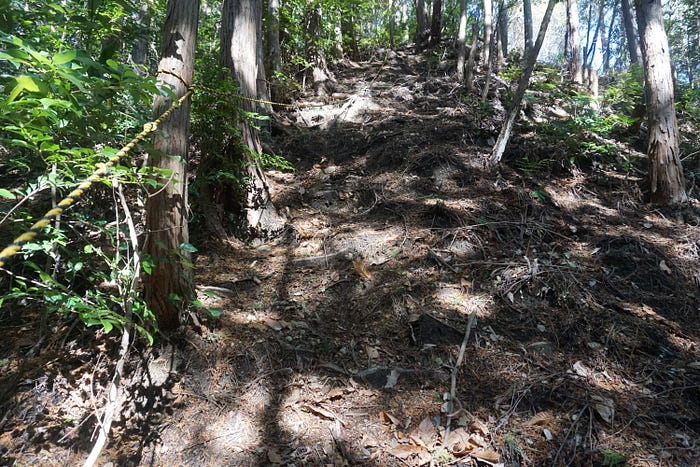
I opted to go left, further into the woods but after half an hour, I felt like I was going in circles. I did find a sign, but it was pointing me in the direction of Hataodake, a local mountain nicknamed the “Fujisan of Amami” since it bears a similar shape to that sacred volcano. I knew this was nowhere near my destination, so I made my way back to the ridge and went right.
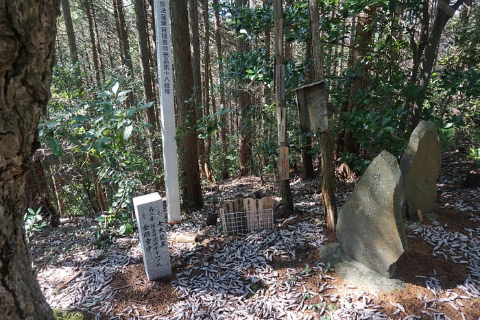
Very quickly the path became so steep that I needed to haul myself up using a rope a previous explorer had fixed to the trees. This was a good sign, and after a 5-minute climb, I crested the top of the hill and reached my goal. I had found Shrine 18 of the Katsuragi 28 Shuku Kyozuka.
The effort to find and reach even just these few locations was surprising; but then it is not supposed to be easy. Even when breaks in the trees were wide enough to allow for internet; their geo-locations were off by several hundred meters, if they were even present. It was nice to go back to basics, a good old fashioned paper map and compass.
I had a genuine sense of satisfaction and achievement as I discovered each one and the long, solitary walk helped me clear my noisome and chaotic mind. It also made me more aware of my surroundings. Knowing that I could only rely on my eyes and experience, I began to more instinctively understand what I was looking for, unlike a normal hike where the goal is often just to get to the top.
The story of En-no-Gyoja is an important part of the history and culture of the city of Kawachinagano and I have crossed his path many times since I came to be here. Whether it be exploring the temples he founded or strolling along overgrown trails, he is never too far away.
The Katsuragi 28 Shuku Kyozuka is a Yamabushi training pilgrimage that is still used to this day, and these curious objects are more like stupa mounds than shrines. At each of the 28 points along this 110km trail, ranging from the island of Tomogashima to the Yamato River, is buried a chapter of the Lotus Sutra and adherents will often recite the corresponding chapter at each point.
